Treaties with
Minnesota Indians


Page Buttons


There were a number of treaties with the same tribes or bands which were signed at around the same time in Michigan and Wisconsin. The treaties which are critical in current court proceedings involving Mille Lacs band's hunting and fishing rights (decided in favor of Mille Lacs, and being appealed by the state of Minnesota, 9 counties, and various tourist vusinesses) are deiscussed (with maps) and the history of the treaties litigations in Wisconsin and Michigan at:

Native American Fishing Rights -- G. Sanger, fish and wildlife expert, who has served in this capacity for Lac Courte Oreilles in the long Voigt   lawsuit prepared a number of essays, a treaties page (with maps), a history of non-Indian opposition, and a page of Q and A type misconceptions commonly held about treaties by non-Indians. His whole linked pageset was prepared for a course in Ethics for graduate students of Natural Resources Management at the University of Minnesota in 1996.

The treaties below primarily affect land located in what is now Minnesota. I've summarized each of them, and they may be clicked to see the whole treaty and its signatories. Treaties will be pulled from a database -- my link contains the searchcommand -- so it won't be instant.

1825 Prairie du Chien -- Multinational peace treaty, drew line between Chippewa and Sioux. This treaty was not a land cession teaty but a necessary predecessor. It sought to place all tribes in the Great Lakes region within boundaries which would then be considered "their land" (for a short while). The ostensible reason for the treaty was a peace treaty primarily between the Ojibwe and Dakota (though other tribes also signed). In actuality it was to introduce the tribes to the concept of bounded regions of territory. The main content of the treaty was to draw a line dividing Minnesota, Wisconsin and Michigan roughly in half, with Ojibwe territory north of the line, Dakota south of it. Once the concept of "this is your territory, inside the line" had been accepted, the land cessions could begin, and did.

Winnebago (Ho-Chunk) Treaties

Although no Ho-Chunk reservations remain in Minnesota, in years before the 1800's considerable numbers of the people lived here. For some years a very small Winnebago reservation was maintained in the southeast corner of the state, administered -- like other small, scattered parcels of Winnebago land -- from the BIA's Ashland, Wisconsin, agency. These two treaties ceded all land in Minneswota

1855 treaty with Minnesota Winnebagoes (Ho-Chunk) cedes 900,000 acres land in Minnesota Winnebagoes keep small reservation in southeastern part of state. asdministered from wisconsin.

1865 Winnebago (Ho-Chunk) cede upper Missouri river, in exchange for land recently ceded by Osages in Nebraska<

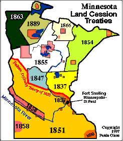
Overview: Minnesota Treaties

This map focusses on treaties, although for many of them reservations were established -- not entirely where they are today. The orange part is the territory the Dakota (Sioux) accepted in the 1826 peace treaty of Prairie du Chien. The main Dakota cession was the Treaty of Traverse des Sioux, 1851, which in effect ceded almost all Dakota territory except for a strip on the Minnesota River. This treaty -- and the fact that a few years later the Minnesota river north strip was taken -- cost Little Crow (Ta-Oyate-Duta) his reputation with many warriors. Ceded areas are marked with dates of treaties, which are summarized (and linked-to in full) below.

Sioux (Dakota) Treaties

1805 Zebulon Pike treaty with Sioux (Dakota) ceded most of Minneapolis and St. Paul -- the land Fort Snelling (and the airport) are located on. Treaty describes the purpose of a land cession as for a military fort.
1837 with Sioux, ceded all land west of Mississippi . Land ceded included Fort Snelling area again. Most of this land cession was located in what's now Wisconsin.
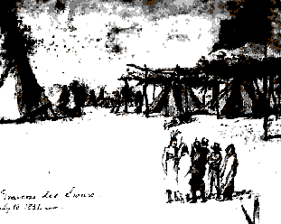
1851 Treaty of Traverse des Sioux -- Infamous treaty, cedes all Sioux land in Minnesota, creates 2 150-mile strips along N and S sides of Minnesota River as reservations. A 19th centuiry artist sketched the meeting for this treaty.
1851 Mendota treaty, Mdewakanton and Wahpekeute -- Same as Traverse des Sioux, 2 other bands signed at Mendota, ceding all Sioux lands in Minnesota and creating 2 strips 150 miles along river as reservation.
1858 senate resolution: The U.S. will pay 30 cents/acre for Sioux 1851 treaty ceded land.
1858 treaty w/Wahpekeute and Mdewakanton, ceded the north strip, allotted the south strip of the Minnesota river. This was the loss of the north strip that finally cost little Crow his reputation with many warriors
1858 Sisseton-Wahpeton, allot the south 150 mile strip Same allottment of the north strip, Sisseton Wahpeton sign on to it.
1858, treaty with the Yankton, ceded the sacrted pipestone quarry There was the provision that Indians would have access to get pipestone there for as long as they wanted to

Sioux Rebellion of 1862

The 1858 treaties that ceded the north strip of the Minnesota river -- and the south strip was to be allotted, which the Dakota regarded as equivalent to losing the land -- cost the leaders who agreed to it their reputations. The Traverse des Sioux treaty had not been considered honorable by many Dakota (and many whites). The Dakota were literally starving. There was nothing to hunt on their diminished lands. Crooked agents and traders withheld annuities and payments.

Although there were warehouses full of food, trader Andrew Myrick at Lower Sioux Agency would not consent to Little Crow's plea to feed the starving people. An almost accidental killing of a farm family by hungry young warriors touched off the so called "Great Sioux Uprising" of 1862. After a few victories, the people were defeated. 38 were hanged at Mankato, still the largest mass execution in U.S. history, and the rest were expelled from Minnesota to the Crow Creek reservation in south Dakota, or the Santee reservation in Nebraska.

Missing: 1863 postwar treaty with all 4 Sioux bands: All Daklota lands in Minnesota are forfeit; the right of occupancy of any land in Minnesota forfeited -- the exile treaty. 12 stat 652. Sale of all remaining Sioux lands in Minnesota 12 Stat 819

Chippewa (Ojibwe) Treaties

Found!: 1826 treaty, Fond du Lac, 7 stat 291, the right to search for and take subsurface minerals -- the mining treaty.

1837 signed at St Peter River ceded all land from north of 1825 line (that divided Sioux and Chippewa, treaty of Prairie du Chien) to Crow wing
1847 treaty with Mississippi and Lake Superior Bands, ceded land intended for Winnebago reervation that was never established. Signed at Fond du Lac
1847 with Pillager Band at Leech Lake ceded land for a Menominee reervation that was never established
1854, with Mississippi and Lake Superior Bands, ceded arrowhead (northeastern portion of Minnesota), and created Grand Portage, Fond du Lac, Lake Vermillion reservations. Signed at Fond du Lac
  • 1858 Fond du Lac modifies 1854 treaty survey, adds back Perch Lake. when the surveyors came to mark off the Fond du Lac reservation, they cut off all the wild rice lakes to the south of it. The band protested that they needed rice and fish for their sustenance, so this letter adds back the southern lakes (but the surveyours removed more land from what's now the city of Duluth).
1855 with the Mississippi, Pillager, Winibigoshish bands cedes all of north central Minnesota in return for reservations to be established in many traditional habitation areas: Leech and Cass lake, Winibigoshish, Mille Lacs, Sandy Lake, Rice Lake, Gull Lake, Rabbit Lake, Lake Pokegama
1863 Red Lake and Pembina bands signed at Old Crossing, Red Lake River, ame3nded in a supplementary treaty of 1864, ceded some land but retained a large tract around Red Lake.
1864 amends 1863 with Red lake and Pemembina bands Red Lakers decline to move anywhere refuse to trade their lands for any others.
1867 treaty with Mississippi Band Chippewa ceded more land off the 1864 treaty boundaries of Leech Lake reservation, establishes the White Earth reservation. This is another concentration camp treaty, everyone is supposed to go there.

Nelson Act of 1899: this is the Minnesota application of the federal Dawes Allotment Act of 1883. A commission was to negotiate the relinquishment of all Indian reservations, except White Earth, which would be allotted in severalty to Indian families who moved there. Red Lake refused allottment, and paid a kind of blackmail: selling the north part of its reservation, in order to stay on their land. White Earth ceded 4 northeastern townships (best farmland, town of Mahnomen).


TOP of
Page
MN Rez
Map
Maps
Menu
MAIN
Menu


Text, maps and graphics copyright -- Paula Giese, 1997 except where elsewhere attributed.


CREDITS:I did the little map and animation and the larger map of treaty cessions. The drawing of the Traverse des Sioux treaty encampment is by an unknown artist who was present and was cropped and enhanced from a Facts on File collection of historical images, made available on web by Prof. Troy Johnson of California State University, Long Beach.

Last updated: 2/6/97