 |
Navajo - Hopi Long Land Dispute |
|---|---|
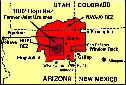
 Cultural differences, a history of U.S. interference, expanding reservation populations, and Peabody Coal are responsible for the longstanding struggle between Navajo and Hopi tribes for certain land and resources. The small map shows the result of a century of Navajo expansion of their tribal lands. Between 1868 and 1991, the Navajo land base has been extended 15 times, mostly at the cost of what Hopi consider their traditional land base, but also incorporating on the northern and western edges of the reservation land of the Utes and Southern Paiutes. It is in the context of this long historical struggle that the highly publicized cause of the Navajo people living at Black Mountain on Hopi land must be understood. At the bottom of this page are links to many sites that present facts and perspectives, mostly in support of the Big Mountain Navajo residents. This short essay attempts to sketch historical background prior to development of the dispute as it is presented today by those crucially involved in it. These 2 maps are adapted -- colored and somewhat cropped -- from 2 presented in The Wind Won't Know Me, by Emily Benedek, Knopf, 1992. Her maps were redrawn from those used in Navajo-Hopi land claim litigations. The rust-colored rectangle in the smallest map shows the boundaries that were set for the Hopi reservation in 1882. The Hopi did not war with the U.S. Unlike the Navajo, they have no treaty. During the years from 1863 to 1868, anglo volunteers under Kit Carson had rounded up about 75% of the Navajos in the area, marching them on death marches to concentration camps at Ft. Sumner in eastern New Mexico. When Navajo leaders signed a peace treaty of 1868, survivors of the long walk (the death marches) began to return. The Hopi began to complain from the very first about Navajo on their land. This led to the 1882 delineation by Executive Order of the 2.5 million acre rectangle (now entirely surrounded by Navajo land) shown in outline on Map 1. At the time of this decree, several hundred Navajo lived on this reduced Hopi reservation. The Hopi have always continued to officially complain about this. The rectangle is greatly reduced from what they always considered their traditional homeland, and they have always officially and legally sought complete jurisdiction over the homeland -- the rectangular 1882 reservation -- that was left. Similarly, Navajo tribal members have always settled families and grazing operations into the remaining Hopi lands. Individual families have in effect "homesteaded" on it without Hopi permission. The larger map, above, shows a marked area at the west of what's now the Navajo reservation marked "disputed area of 1934. " This is the location of the traditional Hopi town of Moencopi. The 8-million-acre area was also later settled by Navajo people, whose town of Tuba City is also shown. This area is outside the rectangular boundary of the 1882 Hopi reservation, and by act of Congress the entire area later became one of the larger expansions of the Navajo reservation. Also included in this Navajo land expansion was all the land of the San Juan band of Southern Paiutes, who have been left without a land base ever since. In obtaining this land for the Navajo tribe, lawyers had argued that "Indians" had lived there since time immemorial.
All this -- villages, farmlands, boundary shrined and other sacred places -- was excluded from the 1882 reservation. Hopi early complaints about the Navajo arose because these comparatively recent arrivals raided Hopi villages and fields. This raiding continued, and perhaps worsened when the survivors returned from the death marches from Bosque Redondo. The surviving released prisoners had virtually nothing to survive on -- families were given 1-2 sheep, they lacked all tools, clothing, and their own plantings had been destroyed. The result of Navajo raiding and Hopi complaints was the rectangular boundary shown -- the 1882 Hopi reservation, which considerably diminishes Hopi territory that had been both in regular use and occupancy and boundary-marked. This marked and formerly used land -- lost by the reservation boundary (though the Executive Order says they shall retain sacred and other individual places) formed the basis of the 1934 Hopi claim to territory the U.S. gave to the Navajo tribe for the western part of their reservation, the marked area on Map 2 which is shown as "1934 disputed territory. " Land from within the rectangle bounding the reservation is the land that 250 Navajo resident families don't want to leave, this is a second dispute or land-taking from the Hopis. Because of disputes about the western 1934 area, when the 1974 Navajo-Hopi land partioning law -- which covers the Hopi reservation, the former Joint Use rectangular area -- was passed, Interior Secretary Bennett placed a "freeze" on construction, development, and even the repair of structures there. The Bennet Freeze (which lasted into the early 1990's, stopped briefly and was resumed in late 1995) is discussed from several perspectives in 1992-94 on the email list NATIVE-L. On April 30, 1992, the Navajo Times reported what was essentially a victory for the Navajo Tribe over the Hopis, in a lawsuit the Hopis had filed over the 1934 disputed western reservation land area. The story was posted to the NATIVE-L email group. (May 1992): Navajo/Hopi: Bennett Freeze Area. Not long after this victory in the lower court, the court ordered an unfreeze on construction in the disputed area. Considerable Navajo building and repairs took place over the next few years. Meanwhile, the Hopi tribe prepared an appeal. In the fall of 1993, a list participant offered information about the Bennet Freeze status that may have been sumarized in an annual report of the American Anthropological Association. In March 1994, Jon Norstog, who does not identify his employers, reported on the 27-year freeze's effects on Navajo western lands residents Norstog's email contains the following: "The Nation assembled a task force to recommend actions when the "freeze" was lifted. One of the recommendations was to decentralize the redevelopment effort, moving it out of tribal government an over to a locally-organized Community Development Corporation, or CDC. This CDC will coordinate redevelopment activities, and would work out of Tuba City. It is designed to take over much of the work now done in Window Rock, like issuing permits, processing homesite and business site leases, taking care of funds, etc. It will be able to go after foundation and state money, and not just be dependent on the feds or the state. "This is a new thing around here. For it to work, a lot of bureaucrats in Window Rock, also the Navajo Nation Council, will have to give up a lot of their power. It will be interesting to see if they can be convinced or forced into doing this." Two months later, in May of 1994, Norstog covers the unfreezing of the freeze and other matters, such as his -- or his employers'?-- view that the Southern Paiutes are really Navajos, shouldn't have been federally recognized as a tribe (as they have been) and shouldn't get any of their land back, at least not from any of what's now Navajo Nation land. Norstog's emails were sent using the email username of "
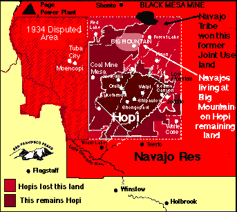
"Jon Norstog works for the Navajo-Hopi Land Commission, an agency of the Navajo Nation. This article updates information contained in FWB Vol. 3, nos. 2 and 3. for more information, contact: Navajo-Hopi Land CommissionPO Box 2549 Window Rock, AZ 86515 tel: (602) 871-6441; fax: 871-7297 E-mail: This is the current P.O. box and phone number and email for the Navajo-Hopi Land Commission at Window Rock, given on the Navajo Nation's Executive Branch government web page. Telephone areacode is now 520. No email is given. Individual current employees are not listed. I looked this up because all Norstog's Internet statements/writings appear to reflect personal views that seemed strange -- situationally inflammatory -- for a Navajo government employee in a sensitive position to be sharing with random World Wide Web readers. From information available to me, I am unable to determine Norstog's actual employer(s) or role or whether his views are authorized expressions or personal opinions. The email address
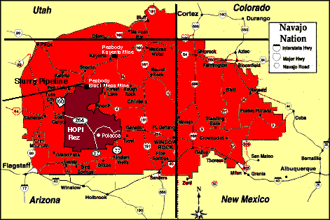
The Hopi court appeal on the Western 1934 disputed lands was finally heard in 1995. Here is the fulltext of the 9th Circuit Court's opinion. In summary: the court held that the lower court was not in error in its holding that the Hopis were not entitled to half these disputed lands just because Congress had given the Navajos half of the lands within the Hopi reservation. But the lower court was in error about Hopi shrines and sacred places on the western disputed lands. That only a few Hopi religious persons used these lands ceremonially, perhaps as seldom as once a year, the court felt, still meant these lands were important religious locations for the Hopi. The court pointed out that in Christianity and many other religions, there are many occasions observed only once a year. The shrines and access to them should be guaranteed in any partitioning of these western lands. The court also refroze the Bennet freeze on construction, setting aside the lower court's thaw, since these lands were (and still are) in litigation at the end of 1995, and the freeze had been set up, in 1974, to prevent substantial changes before litigations were settled. Another land reduction for the Hopis occurred in 1936, this one within the rectangular boundary of their reservation established in 1882 As part of a stock-reduction plan to reduce overgrazing from sheep and goats (mostly Navajo), the BIA divided the Hopi homeland rectangle into 18 land-management grazing districts, of which only one District 6 (about 1/5th of the original divided area) was allocated exclusively to Hopis. The remaining 17 districts within the rectangle were called "Joint Use" districts for both Hopis and Navajo. The Hopis continued to protest this continuing reduction of their homeland. In 1958, a special act of Congress permitted the two tribes to sue each other in their dispute over the land question. The lawsuit, Healing v. Jones was decided in 1962. The Hopis lost it, bigtime. The court ruled that except for District 6 the two tribes had equal rights to the 17 districts within the small rectangle boundary of the 1882 Hopi reservation. Key court finding: "Navajos had squatted on Hopi lands, and because the Secretary of the Interior had never taken action to remove them, they had acquired 'squatters rights' to a one-half interest in the Hopi reservation, surface and subsurface on a share and share alike basis." Observers at the time of this decision felt (and wrote) that it seems to have been influenced by the fact that the Navajo tribe could be expected to be more compliant and friendly to Peabody Coal than Hopis with newly-affirmed Navajo subsurface rights. The coal deals were the basis for the swift rise to power of long-term Navajo tribal chairman Peter MacDonald, who had been appointed (in 1963) to head Office of Navajo Economic Opportunity. MacDonald was elected to the first of his many terms as tribal chairman in 1970. MacDonald was recently released for health reasons from federal prison terms being served for convictions in 1990, 1992 and 1993 for racketeering and corruption charges in relation to land and financial dealings. Peabody Coal was formerly a wholly-owned subsidiary of Kennecott Copper. Many mergers later, it is now part of an empire of coal, owned by a British holding company, Hanson.) Not only was the Black Mesa to be strip-mined, but the Mohave power plant, 275 miles away was to be -- and is -- fed by a liquified slurry of crushed coal pumped along a pipeline that uses 3,000 gallons a minute of precious desert aquifer water, laid down in the deep rocks millions of years ago, before this land was desert. This irreplaceable water is the most valuable of the subsurface rights Peabody acquired access to, and its profligate use is the most threatening to long-term survival of the entire southwest. The water pumping all takes place near the Black Mesa mine (though it can suck water from hundreds of miles away, the entire aquifer). The Peabody Kayenta mine feeds the power plant at Page with dry coal on coal trains. But for Black Mesa, Peabody counts only the cheaper method of delivery, which maximizes its profits, not counting the cost of stolen water to all life in the southwest. The small map shows the result of this decision. The Hopi lands were reduced to the small diamond-shaped area within the rectangle of their 1882 reservation. The Healing v. Jones decision on the Joint Use area gave equal rights to both tribes on the rectangular surround -- the original Hopi reservation boundary. The south central entirely-Hopi area is mostly parts of First, Second and Third Mesas. Fields, grazing areas -- and much of the large Black Mesa coal mine on the northern part of the Hopi reservation that Peabody Coal operates, since receiving Navajo leases for it first, (1965) then a Hopi lease (in 1966) were designated Joint Use, with ownership rights held by both tribes. The Hopi tribe, who had opposed the mine had no choice buut to sign a second lease. the court-s decision giving the Navajo tribe half-rights to the Hopi reservation, including subsurface rights, and the Navajo Nation's signing a coal lease on this land with peabody meant the Hopis' only choice was to receive some royalties, or not. Mining would go forward regardless. Hopis had no employment opportunities at the mine, because the roads were built to access it from Navajo territory, to the north. The mine could not be reached from any of the Hopi villages. A decade later the still-disputed partitioning process was begun in 1974. This divides the Hopi lands that were taken by the BIA in 1930 for Joint Use, and then by the courts declared to be half-owned because of navajo squatters on these Hopi lands. About 50% of the taken land already has been given to the Navajo Nation. The Black Mountain residents live on the other half, that which Hopis were permitted to keep in the paritioning. The partitioning act was described, in 1972, when first put forward: as an end-run around Hopi opposition to Peabody Coal: "Currently a campaign is being waged in Congress to further weaken the Indians' ability to fight the mining of the land. Parts of the Black Mesa mine are on land that is jointly used by the Hopi and the Navajo. The issue of ownership of Black Mesa has been contested in the courts by the two tribes, each claiming full ownership. Traditionals prefer to continue joint use rather than settle the dispute through the U.S. judicial system. The white man, in the person of Congressman Sam Steiger, is unhappy with this solution and has put forward a bill in Congress that would partition the joint use area. The main and most convenient effect of this action would be to place the mine solely in Navajo hands, thus diluting the opposition to Peabody. For it is the Hopi who have been the most outspoken in their opposition to the mine and have filed suit in federal court to halt the mining. Should the mine be stopped, Arizona would lose over half a billion dollars in tax revenues, which may explain Steiger's action." -- Suzanne Gordon, Black Mesa, The Angel of Death,, John Day Company, 1973 In amendments to the 1974 partitioning act, Navajos received an additional 400,000 acres of replacement land -- 75,000 acres of this being a coal mine in New Mexico -- that was supposed to provide homes for relocated Navajos, moved off Hopi partitioned land. A federal Navajo and Hopi Relocation Commission was formed, whose funding has -- over some 20 years -- added up to more than $300,000,000 to assist with relocations of tribal people who were living on lands assigned to the other tribe. This has gone almost entirely to the Navajo tribe , with some to relocate families, who had been living on Hopi land. ANavajo tribal agency, the Navajo-Hopi Land Commission, was established to manage the process. Approximately 11,000 people have been relocated. Most published reports say the numbers of people to be relocated by the land partitioning were 10,000 Navajos -- who had been living within the boundaries of the 1882 Hopi reservation that were partitioned back to Hopi ownership -- and 100 Hopis, who had been living on that part of their 1882 reservation that was partitioned to Navajo ownership. About 250 Navajo families in the Big Mountain area on Hopi land have refused. An ironic sidelight on these relocation numbers is that many non-Indian supporters of the 250 Dineh (Navajo) resisters say it should be Navajo land, because Hopis do not need their land, since they live in villages and support themselves by dryland farming quite close to the rocky mesas where most of their towns are located, while the Navajos do need the Hopi land for their sheep. On its face this is not a legitimate reason for taking someone's land. But the Hopi Tribal Council reported to the Economic Development Administration of the U.S. Department of Commerce in 1995 that: "Farming decreased notably during the 1960's and 1970's, while the population grew to over 7300 by 1990. In 1970, the Hopi Cultural Center opened, as part of an effort to create more employment on the reservation. By 1980, the reservation's economy had begun to shift decisively from one based on subsistence agriculture and sheepherding to one based on wage labor. Jobs exist primarily at area coal mines, in the service industry, or connected to the tourist trade, including the production of crafts such as kachina dolls and traditional pottery." Economic projects reported included "The construction of housing near coal-mining operations, full development of a recently revamped Hopi Industrial Park; the establishment of the Hopi Water Utility Authority (which the tribe would opeate as a business); the renovation of the Hopi Cultural Center Museum, conference room and four craft shops; the commercial development of a 30-acre tract of land at First Mesa; and construction of a small shopping mall at Bacavi Village and a motel-restaurant complex at Moencopi Village." In short, the Hopi people, facing population growth and other changes, need their land just as much as any other people, and have as much right to plan for and carry out such uses as seem beneficial. Peabody Coal operates 2 Arizona mines, one is the Black Mesa mine partly on Navajo and partly on Hopi land, as shown on Map 2. Most employment at this mine is Navajo, because the access roads to it are from the north. Peabody Coal's second mine on the Navajo reservation is north of the Black Mesa mine, at Kayenta. Here is a fact (or propaganda) sheet prepared by the western division of Peabody Coal, a company whose annual revenues are $2 billion. It shows where the electrical power generated from both coal mines (and another on Crow land at Colstrip, Montana) is used -- the distant cities. who benefit, along with the profit-making company. The giant holding company's main web page may also be studied. The U.S. Department of Interior Office of Surface Mining posted on August, 1996, the 1995 coal tonnages of the Navajo and Hopi tribes in Arizona. 15,530,954 tons were also mined from 7 mines in New Mexico, 2 of which are Navajo or on Navajo land, but no separate reports are posted. Litigations and Hopi complaints about the situation continued after the 1960 court decision concerning the Joint Use lands within the 1882 Hopi reservation, which, as the Hopi tribal government saw it, robbed them of nearly half of their remaining homeland, awarding it to both the Navajo nation and what the courts had called Navajo squatters. In 1974, Congress passed the Navjo-Hopi Land Settlement act, that was supposed to partition the Joint Use lands (that lay inside the boundary of the 1882 Hopi reservation). The results of this partitioning -- which is still an ongoing process -- can be seen in the large map, above. The darkest color, the diamond-shape, represents Hopi homelands not as yet challenged by the Navajo tribe or U.S. government. This is primarily First, Second, and Third Mesas, with many the Hopi villages there for more than a thousand years, some established more recently. The medium-red rectangle is the Hopi reservation of 1882 that was turned into a Navajo-Hopi Joint Use area without Hopi consent by the BIA in 1936. Because of long-term Navajo residence and grazing on this land -- again without Hopi consent -- the court awarded all the rectangle-bounded Joint Use Area (except for Grazing District 6) to the joint ownership of both tribes. The 1974 and afterwards partitioning of the Joint Use lands shows in darker color the lands the Hopis have been permitted to retain as exclusively theirs in ownership and jurisdiction, that is a new Hopi reservation boundary. The lighter color inside the 1882 Hopi reservation boundary is lands that were awarded exclusively to Navajo ownership. According to the Hopi Tribal Council, the results of these decisions -- as of 1994 -- had resulted in a loss of about 1,000,000 acres of the original 2.5 million acre reservation, all of this being land transferred to Navajo tribal ownership after first being designated Joint Use land. According to a 1992 lawsuit filed by the Hopi tribe, the Navajo residents did a claimed $59,000,000 of damage to the original Hopi reservation lands that became Joint Use, then were partitioned to the Hopi tribe, through overgrazing mostly by sheep. The pink area south of the Black Mesa mine is the Big Mountain area where a number of Navajo families who have refused to move during the repartitioning process live. This area is entirely partitioned to be within Hopi ownership, within the new (reduced) Hopi reservation boundary. In October, 1996, the two tribes agreed on what is again supposed to be final settlement (reported in the LEGISLATE link below) that includes 75 year leases to be offered by the Hopi Tribe to those Navajo families who do not want to move off Hopi land. But it is Hopi land, the Hopi Nation, not the Navajo nation, will have jurisdiction there. This is not acceptable to the Navajo residents group, but Navajo jurisdiction over any of their remaining land is not acceptable to the Hopi Nation. The Hopi Nation has a substantial legal worry. The result of the 1960 decision gave half rights in all the Joint Use land (original Hopi reservation) to the Navajos on the ground that Navajo squatters had not been evicted, and thereby had acquired ownership rights. There is a real and substantial Hopi worry that permitting the Big Mountain people to remain will eventually result in ownership transfer of this Hopi land too. The compromise has been an offer of long residential leases, which clearly indicate who the actual landowner (the Hopi tribe) is. Unfortunately, the leases contain a variety of clauses that seem to have been formulated to give grounds for speedy eviction, such as having a broken car or truck on one's leasehold. Grazing restrictions, the Navajos say, will not provide for enough sheep to support a family. Other restrictions seem to prohibit the gathering of ceremonially required plants. And some lease restrictions might be interpreted as general violations of civil rights.
This large map shows the boundaries redrawn (by the Navajo tribe) to reflect their perception of the current Hopi-Navajo tribal land boundaries. This is essentially the darker-colored area of Map 2, above., the diminishment of the 1882 rectangular Hopi reservation. I've added the Black Mesa and Kayenta Peabody Coal mines and colored this map consistent with the others. Both tribes share income from Peabody Coal's Black Mesa mine, whose land is leased from both reservations, but only a few Hopis work there, because the roads to it are convenient for Navajo employees, but not for residents of Hopi towns. (The Hopi Tribal council has said "With completion of the Turquoise Trail Highway, the commute from Hopi villages to the mine will be considerably shortened, increasing the possibility for Hopi employment.") About 2600 Navajos work in mining (8% of the total tribal work force). Mining is also the largest revenue sector for the Navajo Nation, $75 million annually in coal/gas royalties. In addition to the Black Mesa mine (which is partly on Hopi land), Peabody Coal operates a larger mine further north -- as shown on the largest map here -- at Kayenta, entirely on the Navajo reservation. This largest map, colored but not otherwise adapted, was furnished by the Navajo nation to the U.S. Department of Commerce Economic Development Administration, and is reproduced with the section on the Navajo Tribe in "American Indian Reservations and Trust Areas," 1996. This map seems to represent official Navajo Nation understanding of a final settlement. Joint Use land has entirely disappeared; we see now the partition outlined as the Hopi Reservation's new boundary, and former Joint Use districts partitioned to the Navajo tribe are shown entirely as a part of that nation. It is in this complex historical context, then, that the widely publicized effort of Navajo families, who have lived at Big Mountain for more than 100 years and wish to stay there in spite of the partitioning of this area to Hopi lands should be viewed. Their cause has been well publicized, books have been written, movies and vids made, and they have a lot of political support, demonstrations, petitions. I have a number of links (below) to these groups. I could not find any presentation of the official Hopi tribal government's position, though there are a number of websites which support Hopis or provide info about them. Mainly they reproduce various prophecies and non-local statements by travelling Hopi elders with Nuage enthusiasm. The main statements pertinent to Big Mountain appear to come from members a traditionalist faction mainly resident at the 3rd Mesa Hopi village of Hotevilla. Their statements say in effect that traditionals of both the Navajo and Hopi groups could have worked things out, but the compliant or puppet tribal council governments of both tribes will not listen. Practical details, and the threatening outside legal/political/economic situation --sketched above here -- are never considered. The above sketch does not present " the official Hopi viewpoint". I don't know what that is, since it hasn't been much publicized. It presents some facts and history that are usually omitted by those who support the Navajo families who have been living on the Big Mountain area of Hopi land. In the paritioning as Navajo or as Hopi, of land which had been made into "Joint Ownership" land by Navajo use never authorized by Hopis, the Hopi Nation lost over 1,000,000 acres of their diminishing homeland to the Navajo Nation. This loss has not benefitted the Navajo residents of the Big Mountain area. For reasons that some state (in Voices from a Troubled Land, linked-to below) the activists do not feel the relocation program has anything to offer that they want. The reason given by the U.S. courts for ruling that nearly half the Hopi reservation should be joint ownership was Navajo squatters' rights. This is the primary reason the Hopi government must insist on full jurisdiction over its remaining land. If it does not do so, the courts may rule again that Hopi people have lost rights to another portion of their ever-diminishing homeland. The widespread publicity and support for Navajos at Black Mountain has paid no attention to this long period in which Hopi lands were cut in half, and given to the Navajo Nation that entirely surrounds Hopi land. Below is a variety of links, starting with one to the October, 1996 latest final settlement report, which included a deadline of December 31, 1996, for Navajo residents to sign Hopi leases or get off the Hopi land. Most of the 250 families who remain have refused. These links indicate the positions and news as reported by both the Navajo Big Mountain supporters and Hopi Hotevilla traditionalists, with some other news reports, declarations of support, and the like. If I find an official Hopi presentation, I will link it here too. I feel that the above history, while it is from no one's viewpoint in the controversy, contains relevant facts that in general have been ignored by most Big Mountain supporters. Recent books of the 1980's and 90's have tended to focus on the land issue as if it were an "Indian vs Indian" fight. In a 1973 book, Black Mesa: The Angel of Death, (The John Day Company), Suzanne Gordon reported on the issue as seen then. At that time, the Big Mountain Navajos were not, or hardly, visible and the issue, as she reported it, was Hopi opposition to the mine and water theft. Here's what Gordon said 2 years before the 1974 Navajo/Hopi partition act: "The [Indian Reorganization Act in 1935] replaced the Indians' traditional form of government, the village chiefs, with Tribal Councils -- a supposedly democratic representative governing body. Under the guise of making the reservations safe for democracy, the Tribal Councils have merely provided the federal government and the developers with 'puppet' governments, easily accessible bodies that will act speedily to grant decisions favorable to industry. Had the village chief system remained intact, such decisions would have required the consent of each village chief, a difficult, if not impossible thing to obtain. "From the beginning of this white man's game, Hopi leaders and a great majority of the tribe, have boycotted the Tribal Council, which has brought not democracy but great divisions in the tribe between 'Progressives' who favor the white man's ways, and 'Traditionals' who prefer the old ways. " In my (distant observer) personal opinion, this distinction no longer exists. No one really favors the white man's ways, everyone understands that these ways are a great danger to survival. The current Tribal councils and government of Hopiland -- a very small Nation as compared to the one that surrounds it, which is in turn very small in comparison to the one that surrounds it -- were caught in a trap which is not of their making. It should be noted that from about 1977 on, councils and delegations of traditional Hopi elders meeting together, and meeting with traditional Big Mountain Navajo elders, have repeatedly said the land dispute can be resolved in traditional ways by traditional people -- who are opposed to development, mining, exploitation of sacred lands, and real estate profiteering. Though this is usually ignored in mainstream media coverage, and in litigations and political dealings, these elders' meetings and statements have been widely covered in the Indian press for at least 20 years. The general perspective of most such Indian press coverage has been that this is not "Indian vs. Indian" but white financial interests (and politicians that service them) playing off Indians against each other to gain financial and other advantages for themselves. Unfortunately, these councils, meetings , speeches express feelings or beliefs, but never have dealt with the practical or legal problems, which are quite real, and cannot be ignored. Because this essay has grown rather long, a quite extensive set of links -- to the Black Mountain support groups, to some Hopi pronouncements and news, and to a number of interesting email discussions --is put on a second page, here. | |
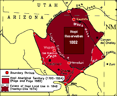 The map at the left shows how these early disputes -- that led to the 1882 Executive order setting the dark rectangular Hopi reservation boundary . Hopis had lived in this area for thousands of year. Before the great drought of 1250, some Hopi relatives inhabited the desert canyon and cliff cities, and when those had to be abandoned, populations resettled in many Hopi Pueblos along the San Juan River (which were wiped out early by diseases introduced by the Spaniards, survivors retreated to the heartland shown). The high mesa area and surrounding canyons and fields were the heartland, a refuge from the Spaniards. This map shows boundary-marker shrines placed by Hopi people about a thousand years ago. Annual ceremonies that certain clans are responsible for renew the sacredness of the heartland to the Hopi people. The darker area shows Hopi land in use in the mid 19th century -- being farmed, small villages, etc. A couple of these villages are marked: Wupotki and Honglavi.